
搜索结果: 1-15 共查到“detailed”相关记录109条 . 查询时间(0.046 秒)

New findings reveal the most detailed mass map of dark matter(图)
Astronomy Physics Research
2023/6/29
For millennia, humans have been fascinated by the mysteries of the cosmos. From ancient civilizations such as the Babylonians, Greeks, and Egyptians to modern-day astronomers, the allure of the starry...

Scientists develop the largest, most detailed model of the early universe to date(图)
早期宇宙模型 黎明女神 Thesan 辐射
2023/6/9
It all started around 13.8 billion years ago with a big, cosmological “bang” that brought the universe suddenly and spectacularly into existence. Shortly after, the infant universe cooled dramatically...

Human facial movements convey emotions, and help us communicate nonverbally and perform physical activities, such as eating and drinking.

Scientists create world's most detailed tornado simulations(图)
Scientists world detailed tornado simulations
2020/8/27
At their most extreme, supercell thunderstorms -- those with persistent rotating updrafts -- can spawn tornadoes, causing widespread devastation.How do tornadoes form? What ingredients do they require...
UTILIZATION OF LARGE SCALE SURFACE MODELS FOR DETAILED VISIBILITY ANALYSES
analysis of visibility unmanned air vehicle 3d point cloud extended viewshed viewshed
2018/3/5
This article demonstrates utilization of large scale surface models with small spatial resolution and high accuracy, acquired from Unmanned Aerial Vehicle scanning, for visibility analyses. The import...
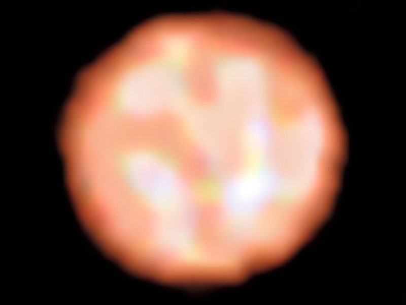
Astronomers Create First Detailed Images Of Surface Of Giant Star(图)
Astronomers Create First Detailed Surface Of Giant Star
2018/2/1
An international team of astronomers has produced the first detailed images of the surface of a giant star outside our solar system, revealing a nearly circular, dust-free atmosphere with complex area...
Detailed new ‘reference’ genome for maize shows the plant has deep resources for continued adaptation
reference genome maize deep resources continued adaptation
2017/7/21
A new, much more detailed reference genome for maize, or corn, as it is called in the U.S., will be published in Nature today. In its accounting of the sequence of DNA letters in the plant’s...
Study provides detailed glimpse of predators’ effects on complex,subtidal food web
glimpse of predators complex subtidal food web
2017/7/20
Research using time-lapse photography in the Galapagos Marine Reserve suggests the presence of a key multilevel “trophic cascade” involving top- and mid-level predators as well as urchins and algae.Th...
BEYOND FLOOD HAZARD MAPS: DETAILED FLOOD CHARACTERIZATION WITH REMOTE SENSING, GIS AND 2D MODELLING
Flood Hazards LiDAR Flood Simulation HEC RAS 2D Modelling
2016/10/14
Flooding is considered to be one of the most destructive among many natural disasters such that understanding floods and assessing the risks associated to it are becoming more important nowadays. In t...
ACCURACY AND SPATIAL VARIABILITY IN GPS SURVEYING FOR LANDSLIDE MAPPING ON ROAD INVENTORIES AT A SEMI-DETAILED SCALE: THE CASE IN COLOMBIA
GPS horizontal accuracy Road inventory Spatial variability
2016/7/8
The accuracy of locating attributes on topographic surfaces when, using GPS in mountainous areas, is affected by obstacles to wave propagation. As part of this research on the semi-automatic detection...
Mortality in vegetarians and nonvegetarians: detailed findings from a collaborative analysis of 5 prospective studies
Vegetarians vegans mortality
2016/6/1
We combined data from 5 prospective studies
to compare the death rates from common diseases of vegetarians
with those of nonvegetarians with similar lifestyles. A summary
of these results was repor...
Chemistry Researchers Unveil New,Detailed Images of Initial Stages of DNA Transcription
Chemistry Researchers Initial Stages DNA Transcription
2016/5/19
An unprecedented molecular view of the critical early events in gene expression, a process essential for all life, has been provided by researchers at Georgia State University, the University of Calif...
Neuroimaging reveals detailed semantic maps across human cerebral cortex
Neuroimaging semantic maps human cerebral cortex
2016/5/6
Here in the functional MRI room at the University of California, Berkeley, it's story time. All in all, getting a brain scan for this project isn't a bad gig -- just kick back, listen to some stories ...
Detailed Digital Surface Model (DSM) Generation and Automatic Object Detection to Facilitate Modelling of Urban Flooding
LIDAR DSM surface runoff Object Detection Surface Characterization
2016/1/25
This paper investigates the necessity of detailed surface representation in order to generate a feasible platform for the detailed
simulation of urban runoff and surface flooding caused by heavy rai...
Close Photogrammetry and Laser Scanning Using a Mobile Mapping System for the High Detailed Survey of a Height Density Urban Area
Mobile Mapping System GPS/INS LIDAR
2015/12/17
The realization of an urban underground is a key issue for the development of any city, and it has to regard all problems linked to the
project phase and the connections with many other works like ra...