搜索结果: 1-15 共查到“water quality”相关记录171条 . 查询时间(0.218 秒)
Calibration and quantifying uncertainty of daily water quality forecasts for large lakes with a Bayesian joint probability modelling approach
BJP large lakes water qualit
2021/7/28
Correcting the systematic bias and quantifying uncertainty associated with the operational water quality forecasts are imperative works for risk-based environmental decision making.

Water quality could be altered in buildings closed during COVID-19 pandemic(图)
quality altered buildings closed during COVID-19 pandemic
2020/4/29
While restaurants, gyms, schools and other buildings are closed indefinitely to prevent the spread of COVID-19, the quality of water left sitting in pipes could change.In buildings nationwide, water l...

Water quality could be altered in buildings closed during COVID-19 pandemic(图)
Water quality altered buildings closed during COVID-19 pandemic
2020/4/26
While restaurants, gyms, schools and other buildings are closed indefinitely to prevent the spread of COVID-19, the quality of water left sitting in pipes could change.
In buildings nationwide, water...

Clear Lakes Disguise Impaired Water Quality(图)
Clear Lakes Disguise Impaired Water Quality
2017/10/25
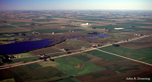
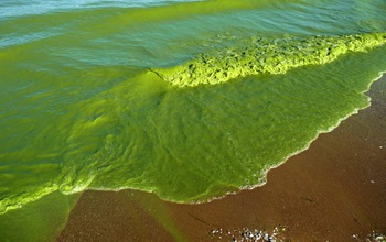
Look at a hundred lakes in the agricultural heartland of the United States and you will likely see green lakes surrounded by green fields. The nitrogen and phosphorus in agricultural fertilizers that ...

Projected precipitation increases are bad news for water quality(图)
precipitation increases bad news for water quality
2017/9/1
Increased precipitation from a changing climate could pollute U.S. waterways with excess nitrogen, increasing the likelihood of severe water quality impairment from coast to coast, according to a new ...
UTILIZATION OF LANDSAT DATA FOR WATER QUALITY OBSERVATION IN SMALL INLAND WATER BODIES
Landsat cloud cover temporal resolution data gap water quality
2016/11/30
Many studies deal with water quality evaluation using remotely sensed data. In the field of remote sensing, there have been proposed several procedures how to observe selected parameters of water qual...
Integrated use of spatial data and learning algorithms to detect water quality trends
Integrated spatial data learning algorithms detect water quality trends
2016/5/20
This paper presents the first results of a study which investigates river basin water quality management based on the ability of GIS to integrate different data sources into a common geographical data...
MODELING WATER QUALITY USING TERRA/MODIS 500M SATELLITE IMAGES
ChlorophyII a Coast MODIS Suspended Solids Turbidity Water quality
2015/12/28
A study was conducted in Hong Kong with the aim of deriving algorithms for the retrieval of turbidity, chlorophyII a and suspended solids concentrations from Terra/MODIS 500m level 1B reflectance data...
A Study of GIS-SD Based Temporal-Spatial Modeling Spatial and Temporal Patterns of Global H5N1 Outbreaks of Water Quality in Water Pollution Accidents
Temporal Spatial Simulation Pollution Decision Support Hydrology
2015/12/1
In this paper, the one-dimension river quality system dynamics model was applied to the water quality simulation, and the conceptual GIS-SD frame was constructed. Based on the component GIS and system...
THE USE OF SPECTRAL SIGNATURES IN EXTRACTING INFORMATION FROM WATER QUALITY PARAMETERS IN THE LAKE URMIA, IRAN
Lake Urmia causeway Landsat燭M water quality parameters
2015/9/8
Lake Urmia, the second hyper璼aline lake in the world, because of its climatic and?
economical importance has燾reated燼 populated region in Iran, and爄n爎eturn its fragile ecosystem?
has?been affected by...
Groundwater Flow Model and Particle Track Analysis for Selecting Water Quality Monitoring Well Sites,and Soil Sampling Profiles
Mechanic villages heavy metals modelling pollution studies Imo River basin
2015/8/14
Researchers often use only surface drainage (imperical method) as a tradition to locate sites for installation of water quality monitoring wells, and soil sampling profile for pollution studies in urb...
Application of Chemical Mass Balance to Water Quality Data of Malaprabha River
Mass balance Salinity advection base flow
2015/8/6
Mass balance calculations carried out for Na, K, Ca, Mg, Cl, SO4 and HCO3 for the study area showed that the major source of contamination is through non-point sources. It is also observed that the ri...
INNOVATIVE FEATURE SELECTION USED IN MULTISPECTRAL IMAGERY CLASSIFICATION FOR WATER QUALITY MONITORING
Remote Sensing ASTER Feature Selection Classifi cation Algorithms Land cover
2015/7/30
For the purposes of our study, an ASTER satellite image was used, acquired on 5 October, 2001, with
14 spectral bands resampled at the spatial resolution of 15 m. The study area concerns the geograph...
LAND USE CHANGE DETECTION AND WATER QUALITY MANAGEMENT IN ISTANBUL’S WATER BASINS BY USING IKONOS IMAGERY
IKONOS Project DEM/DTM Mosaic Urban Building Classification Database
2015/7/29
The aim of the study is producing 1/5000 scaled ortho-images by orthorectifying the monoscopic IKONOS images in the duty area
of the Istanbul Water and Sewage Administration(7500 km
2
area),change...
Satellite Monitoring of Inland and Coastal Water Quality: Retrospection, Introspection, Future Directions
Retrospection Introspection Future Directions
2015/7/23
Note the title of this book. It is about remote sensing of coastal and inland "Case 2" waters, not the open ocean. It is a book of commentary about remote sensing, not a text where you learn how to do...

